Glaring away from the centre-focused destinations of Nepal rests a mysterious pond, engraved with mythical beliefs and traditional sanctity; tucked away beneath the lap of the third highest mountain, Mt. Kanchenjunga, lies Timbung Pokhari, the ‘Gunfire Pond’.
Things to know before your journey to the unsullied lake
Timbung Pokhari is located on the border of Taplejung and Pachthar in the Northeast region of Nepal. The freshwater pond rests at an elevation of 4480m extending in an area of 446m in length and 154m in width. Masked with magnolias Himalayan ranges, the pond stays frozen half the time of the year.
The name ‘Timbung Pokhari’ originates from the indigenous Limbu communal word “Timbak”, meaning the sound produced from a fired gun. The pond was bestowed the name as it made similar sounds from time to time. According to their mythological belief, the gunfire-like sound symbolizes an upcoming bad omen or natural disaster in the region.
Why Timbung Pokhari?
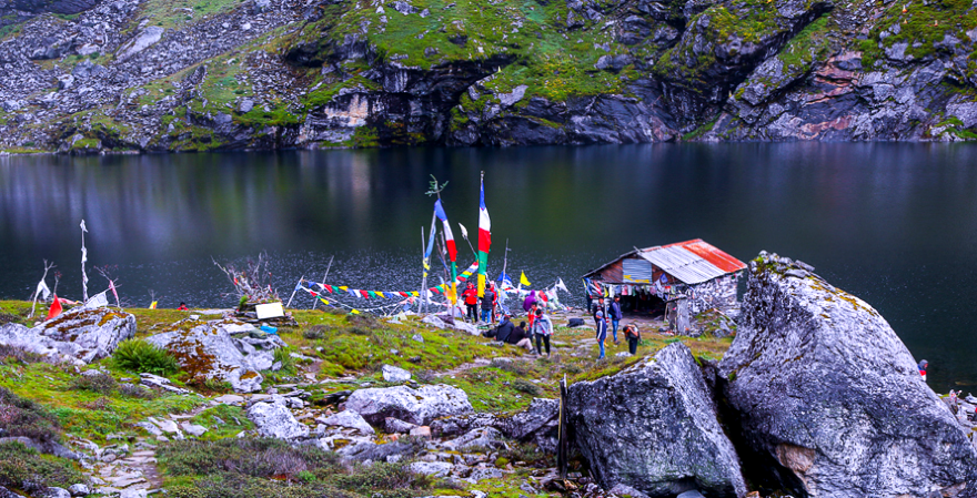
Shrouded with spiritual beliefs, Timbung Pokhari spurts you with the close immersive frame of Mount Kanchenjunga. Bellowing a picturesque landscape of blue ridged mountains and hills, the lake experiences major Indian tourist flow from its neighbouring country India.
Most commonly, travellers from Sikkim, Manipur and West Bengal are experienced visiting this radiant exposure of Eastern Nepal since it falls closest to the international borders.
Besides, the pond welcomes explorers during the Hindu festivals of Nag Panchami and Janai Purnima, particularly in July and August. However, the most desirable month to visit Timbung Pokhari begins from mid of July till September since the season benefits from a stable weather pattern with minimalistic rainfall and clear skies.
Underlying the Kanchenjunga Conservation Area (KCA), the region is home to untainted flora and fauna. Medicinally beneficial herbs such as Kutki, Padmachal, Panchaule, Jatamasi and Panchaule are widespread over the folds of mountain ranges. The spot is fringed by numerous wildlife such as Himalayan blue sheep, bear, snow leopard, red panda and musk deer.
Way to Timbung Pokhari
Timbung Pokhari is a short but strenuous trek filled with rigorous screes and steep slopes that will challenge you physically and mentally. It is crucial to have a formidable guide since the route is underdeveloped and off the grid.
The trek to Timbung Pokhari begins from Betaine, a small village flanked between Taplejung and Panchthar via Falaicha, following the shore of Kali Khola River. The location can be accessed via a jeep ride from Charali, Jhapa, after arriving at Bhadrapur Airport. After a day of jeep ride filled with spectacular views of mountains and waterfalls, the trek duration varies between 3 to 4 days, depending on the experience and physical capability of the traveller.
Additionally, a route under construction via Sandakpur, Ilam, was estimated to connect to Timbung Pokhari. Unfortunately, the development plans were taken down by the Government of Nepal.
Nevertheless, the natives of the region tend to travel via this unofficial route as a shortcut to Illam and Sikkim. Most people use the trail to perform trade and personal activities for their livelihood.
A Guide to Timbung Pokhari
Apart from its luscious vegetation, awe-inspiring scenic beauty and aromatic charm, Timbung Pokhari can be seen as a testament to human will against the merciless nature of the mountains. Due to the lack of development activity in the region, only two homestays are available after you leave Betaini.
However, it is common to find these establishments empty as you reach there since it is run by the locals who might have temporarily left or descended below. Waking towards a higher altitude as you progress, the major difficulties you might face in this trek are hypothermia, altitude sickness and lack of drinkable water.
Considering the uphill route, the most common time to travel falls under the year’s driest season, making it significantly hard to discover a water source. The surrounding ice you might ponder collecting vaporizes during the days, and the river lies far below to scavenge. The simpler challenges in the wildness of nature are perfect for sharpening your will or breaking it. Therefore, we humbly recommend novice trekkers to take local guides of this region to embrace a delicious experience.